This isn't just monitoring—it's actionable intelligence to improve yield, resource use, and resilience in the face of climate variability.
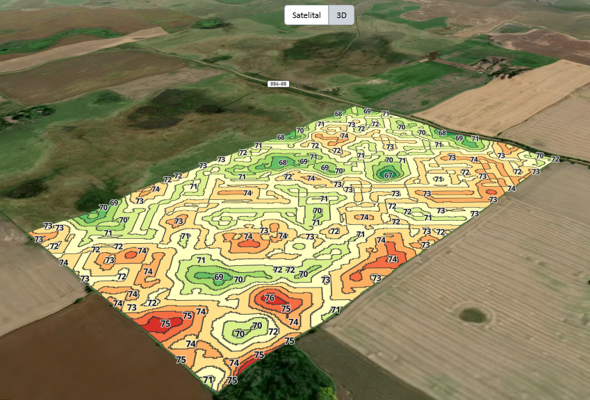
🟫 Soil Maps – Unlock the Power Beneath Your Fields
Our platform provides advanced soil diagnostics through high-resolution, satellite-based mapping. These maps help you understand the spatial variability of your soil — identifying key characteristics such as:
✔️Texture and structure
✔️Moisture retention
✔️Organic matter distribution
✔️Nutrient variability zones
With this insight, you can:
✅Optimize fertilizer application
✅Design variable-rate irrigation strategies
✅Improve crop planning and yield forecasts
All our soil maps are designed to be easy to interpret, actionable, and tailored to your specific land parcels. From precision agriculture to sustainability planning, we provide the tools to help you farm smarter — from the ground up.
🌿 Crop Maps – Monitor Health, Growth & Nutrient Status
Our crop monitoring tools deliver powerful, real-time insights into plant health and productivity across your fields. Using satellite imagery and remote sensing, we generate high-resolution maps that allow you to:
✔️Track biomass development and vegetative vigor
✔️Detect early signs of crop stress, disease, or underperformance
✔️Monitor and analyze key macronutrients and micronutrients including:
✅Nitrogen (N) – growth and chlorophyll production
✅Phosphorus (P) – root development and energy transfer
✅Potassium (K) – water regulation and stress tolerance
✅Magnesium (Mg) – photosynthesis support
✅Manganese (Mn), Calcium (Ca), Sulfur (S), Iron (Fe), Boron (B) – essential for metabolic functions and plant structure
With our dynamic crop maps, you can apply precision interventions, reduce input waste, and optimize nutrient balance for improved yields and sustainability.
Whether you're managing a single field or large-scale operations, our platform turns raw satellite data into actionable agronomic intelligence.
⛰️ Terrain Maps – 3D Elevation and Land Analysis
Our terrain maps provide detailed altimetry and landform analysis using advanced Digital Elevation Models (DEMs) and 3D visualization tools. These models help you understand how elevation, slope, and aspect affect water flow, erosion risk, and crop performance.
With high-resolution elevation data, you can:
✔️Plan efficient irrigation and drainage systems
✔️Optimize field layout and machinery routes
✔️Identify low/high zones for tailored soil and crop management
Our platform also allows you to combine terrain maps with soil and crop layers—giving you a complete, integrated view of your land and helping you make smarter agronomic decisions.